|
|
Solar Maps 3.00 |
|
|
Solar Maps 3.00 |
.
Solar Maps for Microsoft Windows combines simple yet elegant programming with cutting-edge astrological techniques. The result is the easiest and most useful astrological mapping program on the market. Find the best locales for work, love, or the perfect vacation and use the mundane features to know where significant events are likely to occur. Ideal for your own personal use, for mundane work and for enhancing your client work. Here's what the astro-locality experts are saying about Solar Maps:
"Solar Maps is the best all-around mapping program I have used, especially for the beauty of the maps, the zoom and move features to create maps, the fact that you have included Nodes, asteroids, Chiron, and even geodetics!"
—Ariel Guttman, co-author with Jim Lewis of The Astro*Carto*Graphy Book of Maps.
"Solar Maps is the finest program on the market for locational astrology. It allows the astrologer to use the best of the known techniques plus its features also offer the ability to access new and highly practical information."
—Steve Cozzi, author of Planets in Locality.
Technical Features: Solar Maps provides tools for astro-mapping, relocational astrology and local space astrology. Everything is accessible through clear and simple Windows screens and menus. It also has context-sensitive online help and an illustrated, indexed manual of more than 100 pages.
Zodiac Types: celestial zodiac (for normal charts); geodetic zodiac (for mundane charts) with user-definable starting longitude.
House Systems: Campanus, Koch, Meridian, Morinus, Placidus, Porphyry, Regiomontanus, Topocentric.
Chart points: Sun, Moon, Mercury, Venus, Mars, Jupiter, Saturn, Uranus, Neptune, Pluto, Moon's Nodes (mean or true), Chiron, Vesta, Pallas, Juno, Ceres, Hygeia, Astraea, Vulcan, Transpluto, Trans-Neptunians, Black Moon Lilith (mean position). Charts may be calculated for any date from 4000BC to 9999AD. Planets are accurate to several seconds of arc in most cases. The accuracy of Pluto decreases significantly outside the years 1885-2099. Asteroids are accurate to about one minute of arc for 1800 to 2050. You may select any combination of the above points for display on maps or in chartwheels. You may customize the colors used for each chart point.
Time Zones: A database of over 50 standard time zones may be accessed.
Places: A user-expandable database of more than 3000 locations throughout the world may be accessed. The ACS PC Atlas is embedded in this Version of Maps.
Charts: New charts may be cast for dates ranging from 4000 BCE to 9999 CE, and overlaid on maps. Existing charts may be imported from Solar Fire, Nova, Blue*Star, Kepler 2.7 or QuickCharts files. More than 120 charts of famous people are supplied. Charts may be viewed as overlays on any map, in a normal chart wheel, or in a local horizon wheel. Charts may be progressed (by secondary or tertiary rates) or directed by solar arc and overlaid on natal chart angles. Transiting charts may be calculated and overlaid on natal chart angles. Charts may be relocated by selecting a city from the database, or just by pointing and clicking on the map. An AstroClock option allows the display of a chart which is automatically updated at regular intervals. A day/night shading option allows you to see the sun's shadow across the earth, either for any natal chart, or moving in real time with the AstroClock.
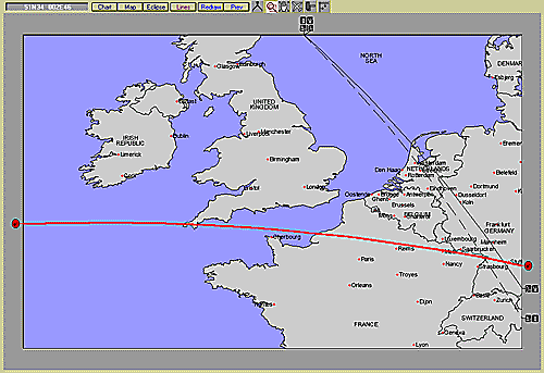
Astro-lines: You can select any combination of the following lines to be displayed on any map: planet on MC; planet on IC; planet rising or on Asc; planet setting or on Dsc; paran lines for any one planet in combination with all others; planet directions; local horizon; local houses; ecliptic; zodiacal signs; total solar eclipse line; partial solar eclipse lines. You can select aspect lines or midpoint lines as well. All planet line types may also be used for any selected fixed stars.
Eclipses: You can select any solar eclipse (partial or total) from 1951AD to 2200AD, and display its path across the earth on any map. Eclipse paths may be overlaid on top of astro-lines for any chart.
Stars: You can select up to 36 stars to be displayed along with, or instead of, planets. A supplied fixed star editor allows you to enter data for any celestial objects of your choice.
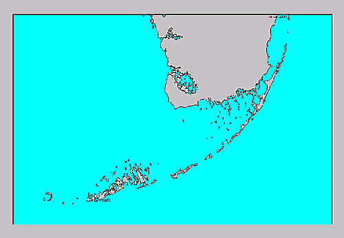
Owners of Versions 1 and 2 of Solar Maps will notice changes in the Map quality as well. Note the detail above for the Florida Keys.
Maps: A selection of pre-defined standard maps is supplied. You can create and save as many new maps as you wish for any region of the world. You can select and adjust the required map region by zooming and panning. Map land and sea colors are fully customizable. You can select and adjust which city and country names are plotted on maps. Click and point to measure distances or angles on any map. You can view the world map in rectangular or Mercator view, or as a sphere. Advanced users can edit the supplied map database, for example, to add features or modify country boundaries.
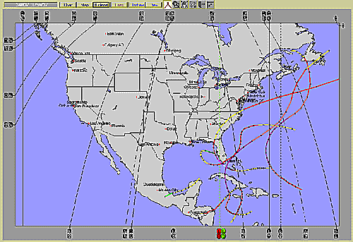
Tracking: This new feature in Version 3 allows you to study geographical hot spots with Solar Maps. The program comes with a database installed of Atlantic hurricanes from 1851 to 2002 – and with the capability to download additional hurricanes from the Unisys web pages. This same system can be used for graphing the locations of earthquakes (or fault lines), volcanoes, or the tornadoes of a particular season.
Reports: For any chart, the following data listings may be viewed: parans interspersed with city names for the current map region; parans interspersed with city names near the latitude of the chart location; cities conjunct or opposite planet lines for the current chart. A one to three-page formatted printable report of interpretive text may also be generated for the relocation of any chart to any location on earth. This includes the following sections: planets which are near angles; conjunction with planet direction lines; paran lines around the latitude of relocation.
Interpretations: May be viewed by pointing to a symbol plotted over or around the map and double-clicking, or by double-clicking on a line of any data-listing report. The following categories of interpretation are included: planet on MC/IC/Asc/Dsc; planets in paran; planet direction lines. All of the supplied text is editable with an included utility program. The text has been written by Esoteric Technologies marketing director and astrologer Stephanie Johnson.
Creative programming gives Solar Maps ultra-clear graphic displays and easy Windows operation putting the fun and ease back into following yourself around the world.
Requirements: 486 or higher IBM-compatible computer with at least 4M RAM;Windows 3.1 or higher running in 386 Enhanced Mode or Windows 95 or higher; cdrom drive; hard disk with at least 5M free; 16 color VGA (or better) monitor (256 colors or more recommended); and a mouse. Printing requires a Windows-compatible black or color printer printing at at least 150 dpi.
An upgrade for owners of Solar Maps Versions 1 or 2 is available for $75 plus postage. In order to qualify for the upgrade, you will need to be a registered owner of either v1.xx or v2.xx. Owners of the mini-maps program which came bundled with Solar Fire v5 are not on this upgrade path and are therefore not eligible. In order to qualify for the upgrade, you will need to provide proof of purchase. Please contact us about means of doing so.